Posted & filed under Surveying.

Land surveying is an essential and important step for any civil engineering project, including freeways, bridges, damns, and similar constructions. It’s mainly necessary in order to establish property lines, note national and state boundaries, chart coastlines, prepare topographical maps, and many other factors that can directly impact a construction project of any size. Mapping the land helps planners and architects navigate the land they’ll be working with and figure out how to best utilize the area.

Through land surveys, professional surveyors are able to collect a host of information that lets civil engineers make educated decisions about their construction jobs, including decisions that affect safety and cost. They’re extremely helpful in selecting a site before construction even begins, as well as noting any potential hazards, flood zones, potentially expensive land grading necessities, and more. Accuracy is of the utmost importance when you’re planning a major project like a road or bridge, and a land surveyor uses a combination of mathematics and technology to ensure that the land is measured as exactly as possible.

Land surveying involves abstract thinking, as well. Outside factors may impact the survey, such as errors in past surveys, changes to the land or water features, or even wildlife crossings. Determining property lines and making sure an area is okay to build on without encroaching on another property or city line can make all the difference between moving ahead with a job or suffering a major (and expensive) setback.

The world around us is constantly shifting in more ways than one, and a survey from even a few years ago may no longer be relevant if an area’s being reconsidered for development. Whether you’re planning the city’s next civil project or you’re looking to construct on private property, land surveying is important for a cost-effective, safe, and accurate outcome. If you have any other questions about how land surveys can help you with your next project, reach out to Cinquini & Passarino anytime.

Posted & filed under Uncategorized.

Survey Mapping

Land surveying has a lot of different uses, one of the most notable being mapmaking. However, not all maps are created equal. There are several different types of maps, all of which serve a purpose for surveying, city planning, construction, and more. The following are some of the most common types of maps created through surveying and what they’re used for. This will help you know whether you’re getting the right map for your project.

Topographic Map

Most people are reasonably familiar with topographic maps, and they’re likely the first kind of map you think of when you think of land surveying. This type of map shows the landscape features of an area, from hills and mountains to lakes and streams. They’re typically structured in such a way that the lines and shading indicate changes in elevation, which is useful if you’re assessing uneven or hilly land.

Resource Maps

While not commonly used in land surveying, it’s possible for civil or corporate projects to need a resource map of a given area. These maps are created to show the natural or agricultural resources located throughout an area, including mineral deposits, farms, natural gas, lumber, and other resources. This information is useful in determining whether it’s safe or legal to construct in a specific area.

Climate Maps

These maps are self-explanatory: they illustrate the climate of an area. They can include temperature readings, snow levels, rain frequency, or even the average number of cloudy days. While this may not be useful in some situations, it can be handy to know if you’re building in an area with a high frequency of rain (and therefore potential for flooding) or snow, which may change the way you need to build.

Flood Maps

A flood map is used primarily by insurance companies to determine areas prone to flooding, which can change premiums for users. It also helps at the civil level for a city to plan for flood control and management, as well as determine when flood alerts should be put in place. Elevation is also a factor, helping determine the safest places to build. Surveyors use flood maps to assist with the preparation of elevation certificates.

Road Maps

This is another familiar sight. These are the maps we use all the time to determine where we’re going and how best to get there, and similarly they can help surveyors determine property boundaries and projected construction.  Many road maps are based upon the land subdivisions created by land surveyors.

It’s always good to know what sort of map you need for your project. A reputable survey company should be able to tell you which type, or types, you’ll need and why. If you’re ever in doubt, just ask. Questions are encouraged!

Posted & filed under Surveying.

Land Survey

When we heard news of the fires affecting Sonoma and Mendocino Counties, as well as several other areas of California, our hearts sank. We know that every other resident in the area can relate. This is our home, and our neighborhoods were not only being devastated by uncontrolled wildfires, they were being devastated at alarming speed. We’re positive we weren’t the only ones glued to the news that entire week and beyond, watching and hoping it would be okay.

Now that the danger has passed, the real question comes to mind: where do we go from here?

For many of our friends, family, and neighbors, this wasn’t just a matter of hoping that their house or business would be okay. They already knew their house wasn’t okay. For them, it’s the beginning of a long process of assessing the damage and figuring out whether to rebuild or move on. This is where the job of a land surveyor comes in, and it’s what we’re here for.

Land surveyors assess thousands of properties every year, both privately and publicly held. Part of our job is letting people and companies know existing conditions of their building site, where their property boundary is located, as many familiar references may have been destroyed, and set or reset property monuments so the corners are readily visiable

If it’s been a while since your property was surveyed and you are planning future improvements, you’ll likely want to have your property surveyed. As land surveyors, we typically focus on small and large scale projects like topographic mapping, corporate projects, city surveying, railroad surveying, and construction surveying. With the widespread damage throughout the area, there’s a lot of work to be done in residential areas, as well as city spaces that were damaged (like Coffey Park) and businesses. Fire damage can cause some serious issues when it comes to the state and cost of the land, so it’s all the more important for professional certified surveyors to be on the job. Before we can rebuild, we need to know how and where.

This is going to be a large, arduous process, but it’s a process we’re here for. We stand Sonoma Strong alongside our friends and neighbors, ready to take on all the challenges the future holds. If you have any specific questions about future surveying or construction, for both residential areas and the cities themselves, please don’t hesitate to ask. We’ll do what we can to answer.

Posted & filed under Mapping.

Parcel Map Waivers for Santa Rosa CABefore you can understand why certain parcel map waivers exist for the city of Santa Rosa, you should understand what a parcel map is. Parcel maps are, in a nutshell, maps that are created by using information that’s been filed with the Town Clerk’s office. Usually surveys are part of this information and are often used to create these maps.

Parcel maps are generally used to determine accurate land size, but they’re often used for a whole host of other reasons, such as determining potential building locations, viewing zoning boundaries, finding floodplain locations, mapping out historic neighborhoods or land, and figuring out the right locations for community services like a fire department. These maps show every parcel of land so that the Town Clerk can record accurate land size and boundaries for the Grand List.

The Grand List is a record of taxable property values within a town, so the Grand List of Santa Rosa will show accurate property values for every taxable portion of the city.

As you can see, almost all of the city’s land, privately owned and otherwise, will need to be recorded on the Grand List. However, there are exemptions, and that’s what we’ll get into now.

According to the Santa Rosa City Code, there are four cases for the waiver of a parcel map. Those exemptions are as follows.

  1. A railroad corporation defined by Section 230 of the Public Utilities Code.
  2. Land conveyed to or from a governmental agency, public entity, public utility, or for land conveyed to a subsidiary of a public utility for conveyance to such public utility for rights-of-way, with some exceptions.
  3. When an official city committee, such as the City Council or Planning Commission, determines that the division of land meets all of the City’s requirements for a number of factors, including floodwater drainage control, improved public roads, water supply availability, environmental protection, and others. A certificate of compliance is required in this case.
  4. The merger of adjoining lots or parcels, except in the case of a city committee determining that a parcel map is necessary.

For the complete section of the Santa Rosa City Code with all details included, you can visit this site.

As you can see, in order to waive a parcel map, very specific requirements must be met and permission usually must be obtained from the city. The necessity of parcel maps makes it all the more clear that surveys should be conducted professionally and with great attention to detail so that the city’s Grand List is accurate and there are no issues obtaining waivers when appropriate.

Posted & filed under Mapping, Surveying.

When you’re looking at a map, you should have some idea of where you’re starting and where you want to end up. Take that same concept and apply it to surveying, and you’ll understand why it’s so important to select the right benchmark and datum for a survey job.

A “benchmark” isn’t just a slang term for a starting point. It’s an actual, literal mark, usually set in stone or concrete, that’s used as a set place for surveys to take place. It originated from the marks themselves, which can be used to place an actual bench for a leveling rod to sit on. The point of creating an actual mark in that spot is so that surveyors know exactly the height and location from which they’re surveying the land. They also know that every time they set their leveling rod, they’re doing so in the exact same place, which helps in determining any changes to the land.

A “datum” is more abstract. It’s a term that’s used in surveying work to create starting points based on a reference surface, like sea level. They can be horizontal or vertical, measuring locations along the surface of the Earth or measuring land height or ocean depth.

The importance in selecting the right benchmark and datum has everything to do with the type of job. For example, when surveying a floodplain to create a floodplain map, surveyors will want to pay special attention to where sea level is and the height of the land. Using the same benchmark for a series of surveys over time helps engineers get a true sense of whether the land is changing throughout the year, notice whether the earth is shifting, or help insurance providers get a better idea of higher risk planes.

Surveying from the same site and using specific datum measurements means that we can monitor the land to determine erosion, places earthquakes may occur (like fault lines), understand why certain areas are at higher risk of flood, notice an increased danger of mudslides, and much more. By understanding where and when to survey, we can create better construction surveys, property boundaries, levee and dam designs, and ensure our measurements are consistent across the board.

For the best level of accuracy and safety, it’s incredibly important to use benchmarks and datums properly. Doing so allows us to ensure measurements are accurate and provide data that helps keep construction crews and service people safe. An experienced surveyor will know how to use these things to their best advantage.

Posted & filed under Civil Engineering, Surveying.

Choosing the Right Surveyor for the Job
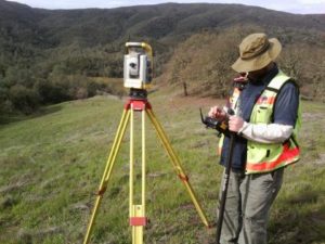
How do you find a land surveyor? More importantly, how do you find the RIGHT land surveyor for the job? There are a lot of factors to consider when you’re trying to choose the land surveying company to assess your property, or boundary lines, or potential construction sites, or anything else. Every job requires a unique set of skills, and you want to make sure you’re going with the right person.

First things first: certification.

The land surveyor you choose to work with should be fully licensed by the State Board for Professional Engineers and Land Surveyors. This is truly a must, because a less qualified individual won’t be legally authorized to either practice surveying or determine property lines. Do your due diligence and make sure your surveyor has their license. It can halt your entire project and cost an arm and a leg to have improper surveying done.

Next, you need to consider the scope of the project. What needs to be done? How large is the job? Make sure you’re working with a surveyor who has experience in the type of work you need done, and ask for all the services that will be provided, including if and how they mark the property lines, as well as how detailed they get and if they offer mapping services. Also, pay attention to your timeline. You want someone who can meet deadlines, but not someone who cuts corners to get things done on schedule. A tighter timeline may require higher pay, so bear that in mind.

That brings us to cost.

Of course it’s important to manage your budget and ensure you’re getting the service you need for a cost you can afford. However, it’s important to make sure you’re not focusing solely on the price tag. Different services have different price points, as well as the complexity of the job and the type of property. It’s more important to have a job done well than done cheaply.

Lastly, you need to make sure you can work with your surveyor professionally. They should be good with communication, offering regular updates and making themselves easy to contact. You want to work with someone who is responsive and willing to answer your questions without too much hassle. At the end of the job, make sure you’re aware of what your owed as far as deliverables. You should get some sort of drawing, plan, or map of the surveyed area showing the fieldwork completed. You’ll want to ask about any other paperwork included in the job and make sure you receive it. Furthermore, it’s always a good idea to ask around or read reviews to make sure you’ll be working with someone who shows a proper level of professionalism.

If you have your list of potential surveyors prepared, give them a call and set up an in-person meeting so you can better get a sense of who they are. Come prepared with all your questions and ask about their previous job. Follow this advice and you’re sure to find a great match!

Posted & filed under Civil Engineering.

These days, everyone’s familiar with drones. You’ve likely seem them in your day to day life, whether it’s a child flying a toy version in a nearby park or a videographer getting a few choice shots at a concert. These Unmanned Aerial Vehicles (UAVs) are excellent for a variety of uses, from recreational to professional, and more and more industries are finding a use for them. That includes civil engineering!

One of the major benefits of drones is their ability to get an aerial view of areas that are normally difficult or impossible to navigate on foot or with land vehicles. When equipped with a camera, drones are capable of surveying these spaces and taking photos to better help engineers gauge the lay of the land. They help spot potential hazards, locate areas of access, and show what’s going on in real-time so that surveyors can make educated decisions about how to approach the land. These images can be shared internally or with sub-contractors so everyone’s on the same page.

Drones are making great leaps and bounds in becoming invaluable assistive technology. An advanced drone can move quickly, hover, and adjust its photographic equipment from the air with the assistance of a remote control. They can also be fitted with sensors that can take any number of readings and transmit that data to a ready analyst. They’re able to achieve great heights to get amazing 360-degree shots of an area, far more than any surveyor could get from a single location on the ground.

Not only are drones convenient and efficient, they’re also environmentally friendly, reducing the need to drive manned vehicles to multiple sites. The images they produce are high-resolution and accurate, providing a current scope of the land. In addition, they greatly reduce the level of risk associated with workers attempting to reach potentially dangerous areas.

All this makes it that much easier and faster to survey potential construction sites or identify property boundaries in more difficult areas. They can also help in cartography, assisting surveyors create some of the most accurate topographic and hydrographic maps possible. For an industry that’s always been heavily reliant on manpower to get the job done, this technology is a very welcome aid.

The question of cost is an important one for any business, and effective drones are by no means inexpensive. However, they’re also not cost-prohibitive, and the potential benefits far outweigh the cost. Many models can be downright affordable when you consider the spared manpower and hours spent surveying. There’s no doubt that this technology is rapidly entering the civil engineering industry, and we have little doubt we’ll start seeing them with regularity soon.

Don’t worry: drones won’t make surveying jobs obsolete. Not every job can be accomplished quickly using drones, so manned surveying jobs will still be frequently used. However, they’ll certainly make the job easier.